
 In
Chambers’ Journal, February 1895, a sailor near Mauritius in the Indian
Ocean reported having seen a vessel which turned out to be an
incredible 200 miles away!
In
Chambers’ Journal, February 1895, a sailor near Mauritius in the Indian
Ocean reported having seen a vessel which turned out to be an
incredible 200 miles away! ERIC DUBAY - Enlightenment From Lighthouses

A copy of the book “The Lighthouses of the World” and a calculator are enough to prove that the Earth is not a globe, but an extended flat plane. The distance from which various lighthouse lights around the world are visible at sea far exceeds what could be found on a globe Earth 25,000 miles in circumference. For example, the Dunkerque Light in southern France at an altitude of 194 feet is visible from 28 miles away. Spherical trigonometry dictates that if the Earth was a globe with the given curvature of 8 inches per mile squared, this light should be hidden 190 feet below the horizon!
The Port Nicholson Light in New Zealand is 420 feet above sea-level and visible from 35 miles away which means it should be 220 feet below the horizon.
The Egerö Light in Norway is 154 feet above high-water and visible from 28 statute miles where it should be 230 feet below the horizon.
The Light at Madras, on the Esplanade, is 132 feet high and visible from 28 miles away, where it should be 250 feet below the line of sight.
The Cordonan Light on the west coast of France is 207 feet high and visible from 31 miles away, putting it 280 feet below the line of sight.
The light at Cape Bonavista, Newfoundland is 150 feet above sea-level and visible at 35 miles, where it should be 491 feet below the horizon.
And the lighthouse steeple of St. Botolph’s Parish Church in Boston is 290 feet tall and visible from over 40 miles away, where it should be hidden a full 800 feet below the horizon!
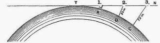
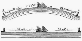 “The
distance across St. George’s Channel, between Holyhead and Kingstown
Harbour, near Dublin, is at least 60 statute miles. It is not an
uncommon thing for passengers to notice, when in, and for a considerable
distance beyond the centre of the Channel, the Light on Holyhead Pier,
and the Poolbeg Light in Dublin Bay. The Lighthouse on Holyhead Pier
shows a red light at an elevation of 44 feet above high water; and the
Poolbeg Lighthouse exhibits two bright lights at an altitude of 68 feet;
so that a vessel in the middle of the Channel would be 30 miles from
each light; and allowing the observer to be on deck, and 24 feet above
the water, the horizon on a globe would be 6 miles away. Deducting 6
miles from 30, the distance from the horizon to Holyhead, on the one
hand, and to Dublin Bay on the other, would be 24 miles. The square of
24, multiplied by 8 inches, shows a declination of 384 feet. The
altitude of the lights in Poolbeg Lighthouse is 68 feet; and of the red
light on Holyhead Pier, 44 feet. Hence, if the earth were a globe, the
former would always be 316 feet and the latter 340 feet below the
horizon!” -Dr. Samuel Rowbotham, “Zetetic Astronomy, Earth Not a Globe!” (59)
“The
distance across St. George’s Channel, between Holyhead and Kingstown
Harbour, near Dublin, is at least 60 statute miles. It is not an
uncommon thing for passengers to notice, when in, and for a considerable
distance beyond the centre of the Channel, the Light on Holyhead Pier,
and the Poolbeg Light in Dublin Bay. The Lighthouse on Holyhead Pier
shows a red light at an elevation of 44 feet above high water; and the
Poolbeg Lighthouse exhibits two bright lights at an altitude of 68 feet;
so that a vessel in the middle of the Channel would be 30 miles from
each light; and allowing the observer to be on deck, and 24 feet above
the water, the horizon on a globe would be 6 miles away. Deducting 6
miles from 30, the distance from the horizon to Holyhead, on the one
hand, and to Dublin Bay on the other, would be 24 miles. The square of
24, multiplied by 8 inches, shows a declination of 384 feet. The
altitude of the lights in Poolbeg Lighthouse is 68 feet; and of the red
light on Holyhead Pier, 44 feet. Hence, if the earth were a globe, the
former would always be 316 feet and the latter 340 feet below the
horizon!” -Dr. Samuel Rowbotham, “Zetetic Astronomy, Earth Not a Globe!” (59)

“The lights which are exhibited in lighthouses are seen by navigators at distances at which, according to the scale of the supposed ‘curvature’ given by astronomers, they ought to be many hundreds of feet, in some cases, down below the line of sight! For instance: the light at Cape Hatteras is seen at such a distance (40 miles) that, according to theory, it ought to be nine-hundred feet higher above the level of the sea than it absolutely is, in order to be visible! This is a conclusive proof that there is no ‘curvature,’ on the surface of the sea – ‘the level of the sea,’- ridiculous though it is to be under the necessity of proving it at all: but it is, nevertheless, a conclusive proof that the Earth is not a globe.” -William Carpenter, “100 Proofs the Earth is Not a Globe” (5)

The Isle of Wight lighthouse in England is 180 feet high and can be seen up to 42 miles away, a distance at which modern astronomers say the light should fall 996 feet below line of sight.
The Cape L’Agulhas lighthouse in South Africa is 33 feet high, 238 feet above sea level, and can be seen for over 50 miles. If the world was a globe, this light would fall 1,400 feet below an observer’s line of sight!
The Statue of Liberty in New York stands 326 feet above sea level and on a clear day can be seen as far as 60 miles away. If the Earth was a globe, that would put Lady Liberty at an impossible 2,074 feet below the horizon!
The lighthouse at Port Said, Egypt, at an elevation of only 60 feet has been seen an astonishing 58 miles away, where, according to modern astronomy it should be 2,182 feet below the line of sight!
“The distance at which lights can be seen at sea entirely disposes of the idea that we are living on a huge ball.” -Thomas Winship, “Zetetic Cosmogeny” (58)

Another great example is the Notre Dame Antwerp spire standing 403 feet high from the foot of the tower with Strasburg measuring 468 feet above sea level. With the aid of a telescope, ships can be distinguished on the horizon and captains declare they can see the cathedral spire from an amazing 150 miles away. If the Earth were a globe, however, at that distance the spire should be an entire mile, 5,280 feet below the horizon!
“In the account of the trigonometrical operations in France, by M. M. Biot and Arago, it is stated that the light of a powerful lamp, with good reflectors, was placed on a rocky summit, in Spain, called Desierto las Palmas, and was distinctly seen from Camprey, on the Island of Iviza. The elevation of the two points was nearly the same, and the distance between them nearly 100 miles. If the earth is a globe, the light on the rock in Spain would have been more than 6600 feet, or nearly one mile and a quarter, below the line of sight.” -Dr. Samuel Rowbotham, “Zetetic Astronomy, Earth Not a Globe!” (59)
A man named Lietenant-Colonel Portlock used oxy-hydrogen Drummond’s Lights and heliostats for reflecting the sun’s rays across stations set up on Precelly, a mountain in South Wales and Kippure, a mountain 10 miles south-west of Dublin. The instruments were placed at the same altitude above sea-level and shined across 108 miles of St. George’s Channel. Technical problems plagued Portlock’s experiment for weeks, until finally one successful morning he wrote: “For five weeks I watched in vain; when, to my joy, the heliostat blazed out in the early beams of the rising sun, and continued visible as a bright star the whole day.” If the world were a globe, Portlock’s light should have remained forever invisible hidden under approximately a mile and a half of Earth’s curvature!
“If we take a journey down the Chesapeake Bay, by night, we shall see the ‘light’ exhibited at Sharpe’s Island for an hour before the steamer gets to it. We may take up a position on the deck so that the rail of the vessel’s side will be in a line with the ‘light’ and in the line of sight; and we shall find that in the whole journey the light won’t vary in the slightest degree in its apparent elevation. But, say that a distance of thirteen miles has been traversed, the astronomers’ theory of ‘curvature’ demands a difference (one way or the other!) in the apparent elevation of the light, of 112 feet 8 inches! Since, however, there is not a difference of 100 hair’s breadths, we have a plain proof that the water of the Chesapeake Bay is not curved, which is a proof that the Earth is not a globe.” -William Carpenter, “100 Proofs the Earth is Not a Globe” (36)
“We are fairly entitled to conclude, therefore, from the reliable data furnished as to how far lights at sea can be seen, that the world is an extended plane, and not the globe of astronomical speculation.” -Thomas Winship, “Zetetic Cosmogeny” (62)
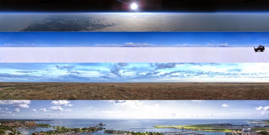
 NASA and modern astronomers claim we are living on an oblate spheroid
25,000 statute miles in equatorial circumference with a curvature of
7.935 inches to the mile, varying inversely as the square of the
distance, meaning in 3 miles there is a declination of nearly 6 feet, in
30 miles 600 feet, in 300 miles 60,000 feet and so on. Therefore, if we
wish to prove or disprove the validity of their convexity claim, it is a
fairly simple, straight-forward matter of measurements and calculations.
NASA and modern astronomers claim we are living on an oblate spheroid
25,000 statute miles in equatorial circumference with a curvature of
7.935 inches to the mile, varying inversely as the square of the
distance, meaning in 3 miles there is a declination of nearly 6 feet, in
30 miles 600 feet, in 300 miles 60,000 feet and so on. Therefore, if we
wish to prove or disprove the validity of their convexity claim, it is a
fairly simple, straight-forward matter of measurements and calculations.
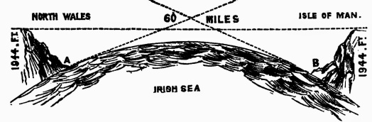
For example, the distance across the Irish Sea from the Isle of Man’s Douglas Harbor to Great Orm’s Head in North Wales is 60 miles. If the Earth was a globe then the surface of the water between them would form a 60 mile arc, the center towering 1944 feet higher than the coastlines at either end! It is well-known and easily verifiable, however, that on a clear day, from a modest altitude of 100 feet, the Great Orm’s Head is visible from Douglas Harbor. This would be completely impossible on a globe of 25,000 miles. Assuming the 100 foot altitude causes the horizon to appear approximately 13 miles off, the 47 miles remaining means the Welsh coastline should still fall an impossible 1472 feet below the line of sight!
“In the Times newspaper of Monday, Oct. 16, 1854, in an account of her Majesty’s visit to Great Grimsby from Hull, the following paragraph occurs: ‘Their attention was first naturally directed to a gigantic tower which rises from the center pier to the height of 300 feet, and can be seen 60 miles out at sea.’ The 60 miles if nautical, and this is always understood when referring to distances at sea, would make 70 statute miles, to which the fall of 8 inches belongs, and as all observations at sea are considered to be made at an elevation of 10 feet above the water, for which four miles must be deducted from the whole distance, 66 statute miles will remain, the square of which multiplied by 8 inches, gives a declination towards the tower of 2,904 feet; deducting from this the altitude of the tower, 300 feet, we obtain the startling conclusion that the tower should be at the distance at which it is visible, more than 2,600 feet below the horizon!” -Dr. Samuel Rowbotham, “Earth Not a Globe, 2nd Edition” (174)

Indoctrinated naysayers will often retort that light refraction off the water’s surface could account for such phenomena. To begin with, the idea that we cannot differentiate between the refracted light of something and the thing itself is preposterous, but even assuming we couldn’t, surveyors’ general allowance for refraction is only 1/12th the altitude of the object observed, making it a completely implausible explanation. Using the previous example of 2,600 feet divided by 12 gives 206, which subtracted from 2,600 leaves 2,384 feet that the tower should have remained below the horizon.

“In September, 1898, I received a letter from Australia in which the writer says: ‘In the year 1872 I was on board the ship ‘Thomas Wood,’ Capt. Gibson from China to London. Owing to making a long passage, we ran short of provisions, and so short after rounding the Cape that the Captain spoke of putting into St. Helena for a supply. It was then my hobby to get the first glimpse of land, make a survey, just as the sun would be rising. The island was clearly in view, well on the starboard bow. I reported this to Capt. Gibson. He disbelieved me, saying it was impossible as we were 75 miles distant. He, however, offered me paper and pencil to sketch the land I saw. This I did. He then said, ‘you are right,’ and shaped his course accordingly. I had never seen the Island before and could not have described the shape of it had I not seen it. St. Helena is a high volcanic island, and if my informant had seen the top only, there would have to be an allowance made for the height of the land, but as he sketched the island he must have seen the whole of it, which should have been 3,650 feet below the line of sight, if the world be a globe.” -Thomas Winship, “Zetetic Cosmogeny” (21)
In
Chambers’ Journal, February 1895, a sailor near Mauritius in the Indian
Ocean reported having seen a vessel which turned out to be an
incredible 200 miles away! The incident caused much heated debate in
nautical circles at the time, gaining further confirmation in Aden,
Yemen where another witness reported seeing a missing Bombay steamer
from 200 miles away. He correctly stated the precise appearance,
location and direction of the steamer all later corroborated and
confirmed correct by those onboard. Such sightings are absolutely
inexplicable if the Earth were actually a ball 25,000 miles around, as
ships 200 miles distant would have to be well over 4 miles below the
line of sight!
 “Astronomers
are in the habit of considering two points on the Earth’s surface,
without, it seems, any limit as to the distance that lies between them,
as being on a level, and the intervening section, even though it be an
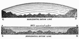
ocean, as a vast ‘hill’ – of water! The Atlantic ocean, in taking this
view of the matter, would form a ‘hill of water’ more than a hundred
miles high! The idea is simply monstrous, and could only be entertained
by scientists whose whole business is made up of materials of the same
description: and it certainly requires no argument to deduce, from such
‘science’ as this, a satisfactory proof that the Earth is not a globe.
Every man in full command of his senses knows that a level surface is a
flat or horizontal one; but astronomers tell us that the true level is
the curved surface of a globe! They know that man requires a level
surface on which to live, so they give him one in name which is not one
in fact! This is the best that astronomers, with their theoretical
science, can do for their fellow creatures – deceive them.” -William Carpenter, “100 Proofs the Earth is Not a Globe” (18, 28
“Astronomers
are in the habit of considering two points on the Earth’s surface,
without, it seems, any limit as to the distance that lies between them,
as being on a level, and the intervening section, even though it be an
ocean, as a vast ‘hill’ – of water! The Atlantic ocean, in taking this
view of the matter, would form a ‘hill of water’ more than a hundred
miles high! The idea is simply monstrous, and could only be entertained
by scientists whose whole business is made up of materials of the same
description: and it certainly requires no argument to deduce, from such
‘science’ as this, a satisfactory proof that the Earth is not a globe.
Every man in full command of his senses knows that a level surface is a
flat or horizontal one; but astronomers tell us that the true level is
the curved surface of a globe! They know that man requires a level
surface on which to live, so they give him one in name which is not one
in fact! This is the best that astronomers, with their theoretical
science, can do for their fellow creatures – deceive them.” -William Carpenter, “100 Proofs the Earth is Not a Globe” (18, 28
“Vast areas exhibit a perfectly dead level, scarcely a rise existing through 1,500 miles from the Carpathians to the Urals. South of the Baltic the country is so flat that a prevailing north wind will drive the waters of the Stattiner Haf into the mouth of the Oder, and give the river a backward flow 30 or 40 miles. The plains of Venezuela and New Granada, in South America chiefly on the left of the Orinoco, are termed Ilanos, or level fields. Often in the space of 270 square miles the surface does not vary a single foot. The Amazon only falls 12 feet in the last 700 miles of its course; the La Plata has only a descent of one thirty-third of an inch a mile.” -Rev. T. Milner, “Atlas of Physical Geography”
 “These
extracts clearly prove that the surface of the earth is level, and that
therefore the world is not a globe. And when we come to consider the
surface of the world under the sea, we shall find the same uniformity of
evidence against the popular view. In ‘Nature and Man,’ by Professor
W.B. Carpenter, article ‘The Deep Sea and its Contents,’ the writer
says: ‘If the bottom of the mid-ocean were laid dry, an observer
standing on any spot of it would find himself surrounded BY A PLAIN,
only comparable to that of the North American prairies or the South
American pampas … The form of the depressed area which lodges the water
of the deep ocean is rather, indeed, to be likened to that of a FLAT
WAITER or TEA TRAY, surrounded by an elevated and deeply sloping rim,
than to that of the basin with which it is commonly compared.’ This
remarkable writer tells of thousands of miles, in the Atlantic, the
Pacific, and the great Southern Ocean beds being a plane surface, and
from his remarks it is clear that A FLAT SURFACE IS THE GENERAL CONTOUR
OF THE BED OF THE GREAT OCEANS FOR TENS OF THOUSANDS OF SQUARE MILES.” -Thomas Winship, “Zetetic Cosmogeny” (23)
“These
extracts clearly prove that the surface of the earth is level, and that
therefore the world is not a globe. And when we come to consider the
surface of the world under the sea, we shall find the same uniformity of
evidence against the popular view. In ‘Nature and Man,’ by Professor
W.B. Carpenter, article ‘The Deep Sea and its Contents,’ the writer
says: ‘If the bottom of the mid-ocean were laid dry, an observer
standing on any spot of it would find himself surrounded BY A PLAIN,
only comparable to that of the North American prairies or the South
American pampas … The form of the depressed area which lodges the water
of the deep ocean is rather, indeed, to be likened to that of a FLAT
WAITER or TEA TRAY, surrounded by an elevated and deeply sloping rim,
than to that of the basin with which it is commonly compared.’ This
remarkable writer tells of thousands of miles, in the Atlantic, the
Pacific, and the great Southern Ocean beds being a plane surface, and
from his remarks it is clear that A FLAT SURFACE IS THE GENERAL CONTOUR
OF THE BED OF THE GREAT OCEANS FOR TENS OF THOUSANDS OF SQUARE MILES.” -Thomas Winship, “Zetetic Cosmogeny” (23)
No comments:
Post a Comment