
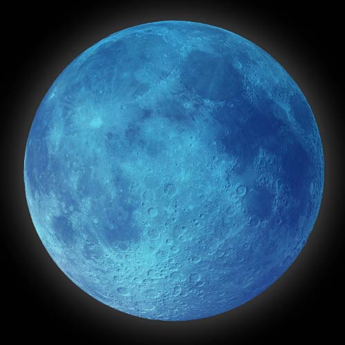
The Full
Moon for this month will occur on Friday, November 19th. The New Moon
is earlier in the month on Thursday, November 4th.
"Pagan" (Non Christian) traditions aside, anyone can benefit from taking the time to self-reflect and to let go. Take advantage of the Full Mourning Moon this November to look back on your year and take stock of your desires, your ambitions, your mental and behavioral habits, and the people you spend your energy on. Clean your living and work spaces, and sort out the physical objects that are not contributing to your well-being. Take the time to fully mourn and let go of anything - or anyone - that does not bring you joy, so that you can begin to move forward, unfettered, towards a lighter and happier new year.
Thursday, May 20, 2021
LEVEL (Flat Earth Film)

It's time for the world to get on our LEVEL:
Produced by Hibbeler Productions: https://www.youtube.com/user/HibbelerProductions
Narrated by Eric Dubay: http://www.youtube.com/c/flateartheric
Featuring O.D.D TV: https://www.youtube.com/user/MrDoseman
Dave Murphy: https://www.youtube.com/user/dmurphy25
Eddie Bravo: https://www.instagram.com/eddiebravo10p/
Santos Bonacci: https://www.youtube.com/user/MrAstrotheology
Tanner Stewart: https://www.youtube.com/c/TStew
Johnny Giampapa: https://www.instagram.com/inkbyjohnnyg/
and more!
If you'd like to support Hibbeler Productions, visit www.levelthefilm.com and stream in HD
Wednesday, January 27, 2021
Modern Polar Discovery Frauds

At the turn of the 17th century, shortly after Queen Elizabeth's advisor John Dee was corresponding with Gerardus Mercator regarding the Polar magnetic mountain, Queen Elizabeth's personal physician and knighted President of the College of Physicians, "Sir" William Gilbert, wrote his Opus "De Magnete," in which he argued against the prevailing belief of a polar magnetic mountain, claiming instead the Earth itself to be a great magnet. Coming in the wake of the Copernican revolution, Gilbert's new model in stark contrast to the long-held, now deemed "unscientific" notion that compass needles were attracted to a loadstone mountain at the Pole, proposed that the Copernican ball-Earth actually generated magnetism from a hypothetical molten metal core, which caused a constantly moving di-polar magnetic field over the globe.
To this day Gilbert's hypothesis remains pure speculation since no one in history has ever come close to penetrating or perceiving the supposed 3950 miles to the ball-Earth's core. In reality the deepest drilling operation in history, the Russian Kola Ultradeep, after decades of work and dozens of broken drills managed to penetrate only 8 miles down, so the entire ball-Earth model taught in schools showing detailed descriptions of a crust, outer-mantle, inner-mantle, outer-core and inner-core layers are all purely speculative as we have never even broken through beyond the crust. Furthermore, there is nowhere in nature that molten metal retains any significant magnetic properties once heated past the "Curie Point," let alone create some convoluted constantly moving di-polar field as Gilbert claimed then and proponents of the globe still maintain today.


Before the alleged 20th century successes, many attempts were made to reach the North Pole during the 19th century all of which failed. In 1827 knighted British Royal Navy Rear-Admiral "Sir" William Parry reached a record 82°45′N latitude before being forced to turn back due to impassable thick ice. In 1845 another knighted British Royal Navy Officer "Sir" John Franklin and his ill-fated two-ship, 129-man crew all died during their attempt at the Pole, after becoming stuck in the ice and everyone subsequently succumbing to starvation, hypothermia, tuberculosis, lead poisoning, zinc deficiency, and/or scurvy. In 1875 yet another knighted British Royal Navy Officer, in fact, the Knight Commander of the Royal Order of Bath, Admiral "Sir" Albert Markham made an attempt at the Pole, reaching a new record 83°20′N latitude before turning back due to rampant scurvy and lack of equipment. In 1895 Norwegian explorers Fridtjof Nansen and Hjalmar Johansen made a record breaking 86°14′N attempt before turning back because of lack of food and supplies. Then in 1899 Duke of the Abruzzi, member of the Royal House of Savoy, and Italian Navy Admiral Prince Luigi Amedeo set another record just barely beating out the Norwegians reaching 86°34′N latitude before becoming stuck in the ice and losing two fingers to frostbite.


Even though Cook's own navigational data was found to be flawed, he would still publicly criticize Peary's alleged sextant readings stating, “Mr. Peary’s polar claim rests upon the impossible observations of a sun at an altitude of less than 7 degrees above the horizon. The three armchair geographers, seldom out of reach of dusty book-shelves, passed upon these worthless observations. Not one out of one hundred thousand honest sextant experts would credit such an observation as that upon which Mr. Peary’s case rests - not even in home regions, where for centuries tables for corrections had been gathered.”


Reminiscent of the 1909 Cook/Peary controversy, however, a similar media-fueled heated debate raged in 1926 as U.S. Admiral Richard Byrd allegedly reached the Pole by plane just 3 days before Roald Amundsen did by dirigible! Both Byrd and Amundsen were aware of each other's concurrent expeditions, and due to recent advances in aviation technology, both decided to reach the Pole via air rather than land/sea as previous explorers attempted. Similar to Scott's follow-up confirmation of Amundsen's South Pole claim, the plan was for Admiral Byrd to fly over first and dump a load of hundreds of large American flags directly at the Pole, which Amundsen would then find and confirm a few days later during his own polar flight.


The final nail in Byrd's coffin came with the 1996 release of his personal diary and papers recording the May 9th, 1926 flight. His official sextant reading typewritten in his June 22nd report to the National Geographic Society taken at 7:07:10 GCT claimed a solar altitude of 18°18'18". In his diary however, an erased but still legible recording shows his apparent observed solar altitude at 7:07:10 to have been 19°25'30". Not only this, but a scrap piece of paper found in Byrd's diary, also in his hand-writing, shows a third scribbled solar altitude for 7:07:10 as being 18°19'18". This intermediate scrap paper calculation between the diary recording and official typewritten report shows evidence of gradual doctoring of the raw data in an effort to fudge a believable figure. In addition, Byrd's official recorded sextant data was overly precise far beyond the capabilities of his or any other sextant available at the time. Dead-reckoning latitudes were recorded with 1000 times better precision than physically possible, again pointing towards an attempt to over-compensate the perceived accuracy of his inaccurate fudged data.


Since Cook, Peary and Byrd's North Pole claims have all been found fraudulent, it is now generally accepted that Roald Amundsen's dirigible flight of May 12th, 1926 did cross the Pole, and he is credited with being the first explorer to both the South and North Poles. Even Wikipedia states that, "three prior expeditions led by Frederick Cook (1908, land), Robert Peary (1909, land) and Richard E. Byrd (1926, aerial) – were once also accepted as having reached the Pole. However, in each case later analysis of expedition data has cast doubt upon the accuracy of their claims." This is also Irish journalist Anthony Galvin's conclusion in his book, “The Great Polar Fraud: Cook, Peary and Byrd - How Three American Heroes Duped the World into Thinking They Had Reached the North Pole.”


The idea of constantly randomly moving Magnetic Poles divorced from their Geographic counter-parts makes it conveniently impossible to independently confirm or deny polar claims by compass. In other words, since the invention of the video camera, any claim to have found the North or South Magnetic Pole, can and should be easily proven. By holding a compass and walking in a circle around the North Pole, the compass should always point directly towards it, and by walking in a circle around the South Pole, the compass should always point 180 degrees away in the opposite direction. To this day, however, no such simple experiment has been performed to prove to the public that these are truly magnetic poles at all.

Why are the annals of Polar exploration so abundant with frauds and hoaxes? Why should we accept all these more recent Polar claims as being legitimate when the original discoveries and discoverers continue being exposed as false and liars? Why is there such an inordinate number of royal knights and Freemasons involved in Polar exploration? Admiral Byrd himself was a high-ranking Freemason from Federal Lodge No. 1 in Washington D.C. and financed by none other than fellow 33rd degree Freemason and Illuminati bloodline elite John D. Rockefeller. Roald Amundsen even had Masonic lodge No. 6-48 in Sacramento, California named after him.
If these explorers truly reached the North Pole, then where is the magnetic mountain, encircling whirlpool, four directional rivers, and surrounding inhabited islands mentioned by Adam of Bremen, Paul the Deacon, Gerald of Wales, Guido Guinizelli, Nicholas de Lynn, Jacobus Cnoyen, Gerard Mercator, John Dee, the Hindus, Buddhists, Jains, Shinto, Taoists, Jews, Christians, Muslims, the Norse, the Egyptians, the Persians and literally every single ancient culture on Earth? Are these all to be discounted as completely false stories with no factual impetus? And if the polar magnetic mountain truly is just fanciful mythology and non-sense, how do we account for this same ("false") concept originating and flourishing independently in nearly every ancient culture worldwide?


Tuesday, November 17, 2020
Early Polar Maps and Exploration

The
ancient world's mythologies regarding a magnetic mountain, four
directional rivers, and other more fantastical features at the North
Pole are shockingly consistent, but what did the earliest known
explorers, historians and cartographers have to say about the subject?
Pytheas, the earliest recorded explorer of the North Pole in the 4th
century BC, claimed to discover an island he called "Thule," the
farthest northern land, and gave an account sounding straight out of
ancient mythology. In his lost book entitled "On the Ocean," Pytheas
wrote, “the island was more than forty thousand stadia, and in this
region there was no longer either land properly so-called, or sea, or
air, but a kind of substance concreted from all these elements,
resembling a sea-lungs - a thing which, the earth, the sea, and all the
elements are held in suspension; and this is a sort of bond to hold all
together, which you can neither walk nor sail upon.” Pytheas claimed
upon reaching the northern-most point accessible, that land, air, and
water somehow became like one substance similar to a jelly-fish and was
completely impassable.
Little remains of Pytheas' original account, but second-hand
sources like Strabo inform us regarding the inhabitants of the
surrounding northern islands, “he says that, of the animals and
domesticated fruits, there is an utter dearth of some and scarcity of
others, and that the people live on millet and other herbs, and on
fruits and roots; and where there are grain and honey, the people get
their beverage also, from them. As for the grain, he says - since they
have no pure sunshine - they pound it out in large storehouses, after
first gathering in the ears thither; for the threshing floors become
useless because of this lack of sunshine and because of the rains.”

Pliny the Elder also wrote of Pytheas’ journey in his Naturalis Historia (IV.16) stating that, “on summer days the sun approached nearer to the top of the world; owing to a natural circuit of light the underlying parts of the earth have continuous days for six months at a time, and continuous nights when the sun has withdrawn in the opposite direction towards winter. Pytheas of Mareilles writes that this occurs in the island of Thule, 6 days voyage north from Britain. Pytheas states that north of Britain the tides rise 80 cubits. The most remote of all is Thule, in which we have pointed out there are no nights at midsummer when the sun is passing through the sign of the Crab, and on the other hand no days at midwinter; indeed some writers think this is the case for periods of six months at a time without a break. One day’s sail from Thule is the frozen ocean called by some the Cronian Sea.”
“The earliest voyage to the north is that claimed for Pytheus, the distinguished Phenician astronomer and geographer of Marseilles, who flourished 320 B.C. His works were extant in the fifth century, but are no longer found. Pliny and Eratosthenes gave full credit to his narrations, though Strabo shows great hostility to Pytheus, whose accounts he refused to receive, saying that he made ‘use of his acquaintance with astronomy and mathematics to fabricate his false narrative.’ Pliny, however, with more reason, thought that he employed his knowledge in practical exploration. The latest editor of Strabo does not share in his author’s doubt. According to Pliny and others, Pytheus sailed through the Straits of Gibraltar, making his way north to the British isles, whither it was the custom of his countrymen to resort, and, after traveling over England on foot, proceeded northward to a place called ‘Thule,’ six days’ sail from the northern part of Britain.” -Benjamin Franklin DeCosta, "Inventio Fortunata, Arctic Exploration With An Account of Nicholas of Lynn" (4)

Even before the 4th century BC, similar claims were made by ancient Greek and Roman poets and historians like Pindar, Herodotus, Hesoid, Homer, (then later Virgil and Cicero) regarding "Hyperborea" and the "Hyperboreans," meaning the place/people "beyond the north wind." They said the people of Hyperborea were giants who lived for over a thousand years and enjoyed lives of perfect happiness. In another lost book written in the 4th century BC, Hecataeus of Abdera collated all the known stories written about the Hyperboreans. Diodorus Siculus references this lost work stating that, "In the regions beyond the land of the Celts there lies in the ocean an island no smaller than Sicily. This island, the account continues, is situated in the north and is inhabited by the Hyperboreans, who are called by that name because their home is beyond the point whence the north wind (Boreas) blows; and the island is both fertile and productive of every crop, and has a temperate climate."

Similar to Thule and Hyperborea, the Celts also had their northern terrestrial paradise known as "Avalon." St. Brandan, son of Finhlogho, a famous saint of the Irish church, who died in 576 AD, was allegedly the first to reach this land during a sea voyage to the North. Similar to other ancient accounts, St. Brandan mentioned a fountain with four directional streams, and claimed there were "magnificent castles and castle halls lighted with self-luminous stones and adorned with all manner of precious jewels, surpassing decription."

They never reached the North Pole or a magnetic mountain, but did encounter an incredible feature long-alleged to surround them. Ancient Norse legend states that a gigantic violent maelstrom (whirlpool) known as "Hvergelmir" or "the World's Well," surrounds the polar mountain and via four, six-hour daily cycles of pushing and pulling through subterranian channels, cause the rising and falling of tides on Earth. Adam of Bremen recounts the Frisian explorer's deadly encounter with this "abysmal chasm," as such: "of a sudden they fell into that numbing ocean’s dark mist which could hardly be penetrated with the eyes. And behold, the current of the fluctuating ocean whirled back to its mysterious fountainhead and with most furious impetuosity drew the unhappy sailors, who in their despair now thought only of death, on to chaos; this they say is the ‘abysmal chasm’ - that deep in which report has it that all the back flow of the sea, which appears to decrease, is absorbed and in turn revomited, as the mounting fluctuation is usually described. As the partners were imploring the mercy of God to receive their souls, the backward thrust of the sea carried away some of their ships, but its forward ejection threw the rest far behind the others. Freed thus by the timely help of God from the instant peril they had had before their eyes, they seconded the flood by rowing with all their might."

Giraldus Cambrensis or "Gerald of Wales," archdeacon of Brecon, historian, and royal clerk to King Henry II, wrote in his 1188 work "Topographia Hibernica" that, "Not far from the islands, towards the north, there is an astonishing whirlpool in the sea, towards which there is a set current of the waves from all quarters, until, pouring themselves into nature’s secret recesses, they are swallowed up, as it were, in the abyss. Should a vessel chance to pass in that direction, it is caught and drawn along by the force of the waves, and sucked by the vortex without chance of escape. There are four of these whirlpools in the ocean, described by philosophers as existing in the four different quarters of the world; whence it has been conjectured that the currents of the sea, as well as the winds, are regulated, by fixed principles."

The whirlpool was also mentioned in another late 12th century work "Historia Norwegiae," where the author, an anonymous Norwegian monk gives a particularly detailed description, stating: "The greatest of all whirlpools is to be found there, which engulfs the strongest ships, sucking them in at ebb tide and spewing out their fragments with a belch at flood tide ... There is a very deep abyss in the earth itself and alongside it are open-mouthed caverns containing winds which are said to be brought forth by the breathing of the water, and these are the breath of gales. Indeed, by their breathing these winds draw to them the waters of the sea through hidden passages in the earth; they shut them up in the vaults of the abyss, and then by the same force drive them out again, causing sea-surges, spates and the whirling of waterspouts. Earthquakes also occur and various discharges of vapour and conflagration, for when the winds’ breath, held in the cheeks of earth, presses to burst out, it shakes the foundation of the world with a dreadful roaring and forces it to tremble. So when the winds’ breath contends with fire in the earth’s interior, then even in mid-ocean the depths are fissured and smoky exhalations and sulphurous flames are seen to emerge."

By the 13th century A.D. the idea of a magnetic mountain at the North Pole was widely known enough that Italian poet Guido Guinizelli actually used it as a simile for the power of his woman's love. The section from his poem "Madonna, The Fine Love I Give you," translated reads, "In that land beneath the North Wind / are the magnetic mountains / which transmit to the air their power / to attract the iron, but because it is far away / it needs help from a similar stone / to make the compass needle / turn towards the pole star."
In the 14th century two lost books "Inventio Fortunata" by Nicholas de Lynn and "The Itinerium" of Jacobus Cnoyen mention the magnetic mountain, four directional rivers, and encircling whirlpool said to change every 6 hours causing the tides, comparing them to the “breath of God” at the “naval of the Earth,” inhaling and exhaling the great seas. Many citations from the two books are made by more modern sources, but surviving copies have unfortunately all been lost to antiquity.

Nicholas de Lynn was an English Minorite friar of Oxford, a mathematician, astronomer and explorer who lived from 1330 to 1390. He was fascinated by the astrolabe and actually produced several of them for patrons and his own personal use. John of Gaunt, Duke of Lancaster, even comissioned Nicholas to produce an astrolabe and a "Kalendarium" of complete astronomical tables covering 1387 to 1463 which were later used to create nautical almanacs. For this Nicholas became famously known as "The Man with the Astrolabe," and was even complimented and lauded as an astronomical genius by Geoffrey Chaucer in his "Treatise on the Astrolabe." His esteem as a knowledgable astronomer and navigator soon reached King Edward III who in the early 1360s sent Nicholas and a team of ships to explore the Arctic.

“The work by which Nicholas of Lynn will longest be remembered is not now to be found. Its disappearance under any circumstances is not a matter of surprise, since of many important works once well known no copy remains today, while of others there are only one or two examples. Unfortunately, we know almost as little about the voyages made from Lynn by the fellow townsmen of Nicholas as about the book in question. Many hardy mariners sailed from the port of Lynn, but of their enterprise at the north only the most scanty memorials remain. It is nevertheless clear that their activity was appreciated by Edward III, while their neighbors of Blakeney were several times favored by that king on account of their superior merit.” -Benjamin Franklin DeCosta, "Inventio Fortunata, Arctic Exploration With An Account of Nicholas of Lynn" (19)


On the legend of Ruysch's map Nicholas de Lynn's Inventio Fortunata is referenced as it's source, stating that, "It is written in the Book of the Fortunate Discovery that, under the Arctic Pole, there is a high magnetic rock 33 German miles in circumference. A surging sea surrounds this rock, as if the water were discharged downward from a vase through an opening to four mouths below. Around are islands, of which two are inhabited. Mountains vast and wide surround these islands, 24 of which deny habitation to man." Another inscription on Ruysch's map describes the incredible magnetic effect of the polar lodestone mountain, stating, "Here the ship's compass loses its property, and no vessel with iron on board is able to get away."

"A world map by Johannes Ruysch, the Universalior cogniti orbis tabula, published in an edition of Ptolemy's Geographia in Rome in 1508, shows four islands around the North Pole; two (the one north of Greenland and its opposite across the Pole) are labeled "Insula Deserta"; the one north of Europe is that of the Hyperboreans; and the one north of America is labeled "Aronphei." He labels the waters within the four islands as the "Mare Sugenum," and speaks of a violent whirlpool that sucks the incoming waters down into the earth; in addition, his map shows a ring of small, very mountainous islands around the four islands, which numerous islands Ruysch says are uninhabited." -Chet Van Duzer, "The Mythic Geography of the Northern Polar Regions"

“This would seem to indicate that the book written by Nicholas of Lynn was known to the mapmaker, while, also, it may have been known at Rome. It is evident that the polar region was drawn more or less in accordance with some plan by Nicholas, which was combined with later material. Around the magnetic rock, immediately under the pole, are four islands, ‘Aronphei,’ ‘Insvla deserta,’ ‘Hyperborei Evropa’ and ‘Insvle Deserta.’ Outside of these islands are smaller and mountainous islands, arranged in a semi-circle, while the peninsula of ‘Pilapelanti,’ with its base resting upon Europe, pushes out into this druidic arrangement of islands, bearing up what is intended to represent a church, with the legend ‘Sacte Odulfi.’ Eastward of this peninsula is the ‘Provicia obscura,’ and the ‘Marc Svgenvm.’ Westward of ‘Bergi extrema’ another peninsula enters the groups of islands, which is pierced by ‘planora de Berga’ at the extreme west. The ‘Mare Svgenvm’ also fills the west. South of ‘Grvenlant’ is ‘Terra Nova,’ or New Foundland. From the ‘Mare Svgenvm’ the water flows northward through the four openings into the polar basin. The arrangement is curious, yet not wholly without resemblance to what is found in nature; for what is called the polar basin is fed by several vast streams pouring into it from the warm regions at the south. These streams also create counter currents, which flow southward, bearing enormous quantities of the heaviest ice." -Benjamin Franklin DeCosta, "Inventio Fortunata, Arctic Exploration With An Account of Nicholas of Lynn" (22)

Swedish historian Olaus Magnus wrote of both the magnetic mountain and surrounding whirlpool in his 1555 work "Historia de Gentibus Septentrionalibus" (A Description of the Northern Peoples) stating it to be a well-known fact that ships in the north must be built with wooden pegs, as iron nails would be pulled out by the northern lodestone mountain, and that, "between Roest and Lofoten is so great an abyss, or rather Charybdis, that it suddenly swamps and swallows up in an instant those mariners who incautiously approach. Pieces of wreckage are very seldom thrown up again, and if they come to light, the hard material shows such signs of wear and chafing through being dashed against the rocks, that it looks as if it were covered with rough wool."

Just two years later in 1557, English explorer Anthony Jenkinson also wrote of the whirlpool, saying, "Note that there is between the said Rost Islands and Lofoot, a whirle poole called Malestrand, which from halfe ebbe untill halfe flood, maketh such a terrible noise, that it shaketh the ringes in the doores of the inhabitants houses of the sayd islands tenne miles off. Also if there commeth any whale within the current of the same, they make a pitifull crie. Moreover, if great trees be carried into it by force of streams, and after with the ebbe be cast out againe, the ends and boughs of them have bene so beaten, that they are like the stalkes of hempe that is bruised."

A few decades later in 1591, Schönneböl, a man who was sheriff of Lofoten and Vesteralen for over twenty years, wrote a similar description claiming that, "Iron rings on house doors are shaken hither and thither by the rushing of the current. Whales who cannot go forward on account of the strong stream, give a great cry and then are gone. And great trees, spruce or fir, which disappear in this current, and when at last they come up again, then all the boughs, all the roots and all the bark is torn off, and it is shaped as though it had been cut with a sharp axe."

The most famous map-maker who ever lived and likely the only person in the history of cartography to become a household name, Gerardus Mercator, known for his meticulous accuracy and responsible for the popular "Mercator projection," lived from 1512 to 1594 and created hundreds of detailed maps. The year after his death in 1595 his family compiled his life's work into an Atlas which included never before released reproductions of Nicholas de Lynn's maps of the polar regions, specifically the "Septentrionalium Terrarum Descriptio." This incredible map shows the polar magnetic mountain "said to be the highest in the world," named "Rupes Nigra," encircling whirlpool, 4 directional rivers, and surrounding islands in fine detail along with several revealing inscriptions.

"The map shows a North Pole that is very unfamiliar to modern eyes. At the center of the map, and right at the Pole, stands a huge black mountain; this mountain was made of lodestone, and was the source of the earth's magnetic field. The central mountain is surrounded by open water, and then further out by four large islands that form a ring around the Pole. The largest of these islands perhaps 700 by 1100 miles, and they all have high mountains along their southern rims. These islands are separated by four large inward-flowing rivers, which are aligned as if to the four points of the compass - though of course there is no north, east, or west at the North Pole: every direction from this center is south. Mercator's notes inform us that the waters of the oceans are carried northward to the Pole through these rivers with great force, such that no wind could make a ship sail against the current. The waters then disappear into an enormous whirlpool beneath the mountain at the Pole, and are absorbed into the bowels of the earth. Mercator also tells us that four-foot tall Pygmies inhabit the island closest to Europe." -Chet Van Duzer, "The Mythic Geography of the Northern Polar Regions"


There is modern circumstantial evidence that lends strong credence to this idea as well. The largest publicly-known maelstrom in the world is called Saltstraumen just North of the Arctic circle in Norway, where 400 million cubic meters of water pass through a 3km long, 150-meter wide strait reaching speeds of 10 meters per second. Similar to legends of Hvergelmir, this Northern whirlpool actually arises exactly 4 times per day, every 6 hours, along with the shifting of the tides! In fact, the majority of naturally occuring whirlpools in the world, including the famous Naruto whirlpools in Japan, form 4 times per day, every 6 hours, as the tides change.

If
the entire ancient world's mythologies along with early explorers,
historians and cartographers all shared similar accounts of a polar
magnetic mountain, encircling whirlpool, four directional streams, and
surrounding islands occupied by giants and/or pygmies, why is it that no
modern accounts of the North Pole have a single mention of any such
thing? How is it possible for such consistency in polar geography to
exist throughout the ancient world? Why have all of these features
suddenly disappeared from modern maps? Were the ancients all completely
mistaken with regards to the North Pole, or are we now in modern times
the victims of a concerted cover-up, and being deceived about what is
really at the Pole?

About Me

Support Independent Media!
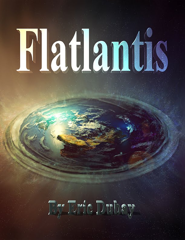
Flatlantis

200 Proofs Earth is Not a Ball

The Earth Plane
The Flat-Earth Conspiracy

Spiritual Science

The Atlantean Conspiracy

Other Sites by Eric Dubay

EricDubay.com
.

Bangkok Wing Chun
.

Eric's Esoterics
Subscribe To Atlantean Conspiracy
Leaders
Attention à ne pas confondre la Toussaint et le jour des morts
 La Toussaint vise à célébrer tous les saints, connus comme inconnus. [DAMIEN MEYER / AFP]
Alors qu'un nouveau confinement s'applique en France pour au moins quatre semaines, le gouvernement a décidé de laisser les cimetières, les fleuristes et les lieux de culte ouverts exceptionnellement pendant le week end de la Toussaint.* Si beaucoup vont en profiter pour aller se recueillir auprès de leurs défunts proches, le jour des morts est en réalité officiellement célébré le 2 novembre. Ce jour de deuil et la Toussaint sont deux commémorations différentes, que l'on a souvent tendance à confondre.
* EVIDENCE THAT THE PANDEMIC WAS FAKE!!!
la toussaint
La Toussaint est une fête catholique, célébrée le 1er novembre. Contrairement à d’autres grandes fêtes chrétiennes, elle ne trouve pas son origine dans les textes bibliques. Longtemps célébrée quelques jours après la Pentecôte, elle a été créée pour commémorer tous les martyrs. Si certains ont eu une reconnaissance, par la procédure de canonisation, l’Église considère que beaucoup d’autres ont vécu au service de Dieu sans pour autant être reconnus. C’est pourquoi, la Toussaint vise à célébrer tous les saints, connus comme inconnus.
À partir de l’an 610, la Toussaint était célébrée le 13 mai. Ce jour-là, le pape Boniface IV a fait transporter au Panthéon de Rome, ancien temple païen, les reliques des martyrs, et a transformé le Panthéon en l’église Sainte-Marie aux Martyrs. Au VIIIe siècle, le pape Grégoire III a déplacé la date de la Toussaint au 1er novembre, jour où il a dédicacé une chapelle de Saint-Pierre de Rome en l’honneur de tous les saints. Vers 835, le pape Grégoire IV a ordonné que la fête soit célébrée dans toute la chrétienté. Ce n’est au XXe siècle, sous le pontificat de Pie X, que la Toussaint entre dans la liste des huit fêtes chrétiennes, avec obligation d’entendre la messe.

Depuis son instauration, la Toussaint a toujours fait partie des 50 jours chômés du calendrier catholique. Si elle a été supprimée pendant la Révolution française, pour amoindrir l'influence de l'Eglise, elle a été réinstaurée en 1802 par Napoléon. Elle fait donc partie des onze jours fériés listés dans le Code du Travail.
le jour des morts
Célébré le 2 novembre, le jour des morts suit directement la Toussaint, mais a été créé plus tard, en 998. Le monastère bénédictin de Cluny avait alors instauré la commémoration de tous les défunts, et non pas seulement des martyrs. C’est au XIIIe siècle que l’Eglise a inscrit ce jour dans son calendrier universel. C’est l’occasion pour les catholiques d’aller fleurir les tombes de leurs proches. Contraitement à la Toussaint, le jour des morts n'est pas un jour férié.

Les défunts sont célébrés différemment dans d'autres religions et culture. Au Mexique par exemple, «el Día de los muertos» est une grande fête durant laquelle les familles se réunissent autour des tombes de leurs proches avec des offrandes, de la nourriture, au son de la musique des mariachis.
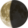 October 29 Waning Crescent 43% | 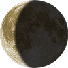 October 30 Waning Crescent 33% | TODAY 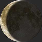 Waning Crescent Illumination: 24% | 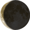 November 1 Waning Crescent 15% | 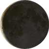 November 2 Waning Crescent 8% |
Moon Phase Today: October 31, 2021
The Moon's current phase for today and tonight is a Waning Crescent phase. In this phase the Moon’s illumination is growing smaller each day until the New Moon. During this part of the Moon cycle, the Moon is getting closer to the Sun as viewed from Earth and the night side of the Moon is facing the Earth with only a small edge of the Moon being illuminated. This phase is best viewed an hour or 2 before the sunrise and can be quite beautiful if you're willing to get up early. It can also be a great time to see the features of the Moon's surface. Along the edge where the illuminated portion meets the dark side, the craters and mountains cast long shadows making them easier to observe with a telescope or binoculars.
Visit the October 2021 Moon Phases Calendar to see all the daily moon phase for this month.
Today's Waning Crescent Phase
The Waning Crescent on October 31 has an illumination of 24%. This is the percentage of the Moon illuminated by the Sun. The illumination is constantly changing and can vary up to 10% a day. On October 31 the Moon is 24.73 days old. This refers to how many days it has been since the last New Moon. It takes 29.53 days for the Moon to orbit the Earth and go through the lunar cycle of all 8 Moon phases.
The 8 Lunar Phases
There are 8 lunar phases the Moon goes through in its 29.53 days lunar cycle. The 4 major Moon phases are Full Moon, New Moon, First Quarter and Last Quarter. Between these major phases, there are 4 minor ones: the Waxing Crescent, Waxing Gibbous, Waning Gibbous and Waning Crescent. For more info on the Moon Cycle and on each phase check out Wikipedia Lunar Phase page.
November 2021 Moon Details
The Full Moon for this month will occur on Friday, November 19th. The New Moon is earlier in the month on Thursday, November 4th.
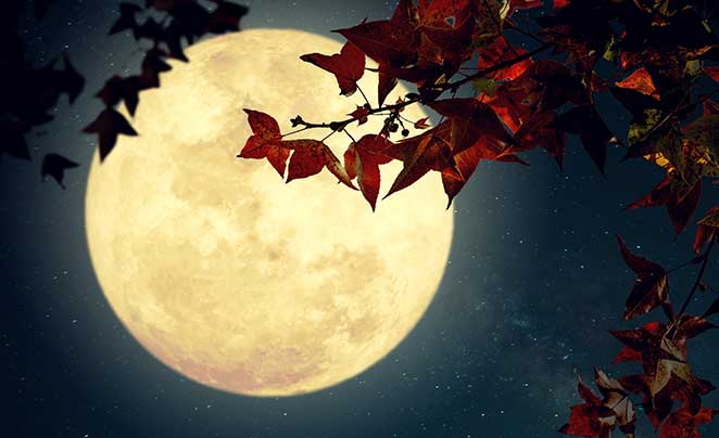
About November's Full Moon
With the changing of the seasons, November’s full moon marks the beginning of the end. This year, it is the very last full moon before the winter solstice, which makes it the Mourning Moon according to Pagan tradition. In many different cultures, November’s full moon is intimately connected with death and loss, on both a literal and symbolic level. The Celts, for instance, called it the Reed Moon, comparing the mournful music made by wind instruments to the ghoulish sounds of spirits being drawn into the underworld. And not without good reason - the Full Mourning Moon marks a dangerous time of the year where people could easily slip into the underworld with a single misstep.
We may enjoy the luxury of winter coats and central heating now, but freezing to death during the long, dark winters used to be a very real threat to early inhabitants of Northern America. In order to survive, making warm winter clothing out of beaver fur was crucial for American colonists and Native American tribes. This is why November’s full moon is also known as the Beaver Moon. During this month, beavers are very active, working hard on dam construction, and so this was a good time to start harvesting their fur.
Missing the timing for this would mean death for these early
Northern American communities, as the rivers would freeze over, making
it impossible to set out traps. Many Native American tribes, including
the Cree, Arapaho, and Abenaki tribes, called November’s full moon the
“Moon When Rivers Start to Freeze”. This name drives home the importance
of November’s full moon as a signal for these Native American tribes to
begin trapping beavers before it was too late, as well as to complete
their preparations for the darkest
For the Pagans, on the other hand, the final stage of their winter preparations involve the very important process of “mourning” - which is why they call the last moon before the winter solstice the Mourning Moon. After a full year of accumulating possessions, both physically and otherwise, the Mourning Moon is the perfect time to let go of old, unnecessary things, while giving yourself permission to mourn their passing. Practicing Pagans may perform a moonlit ritual where they write down the things they want to rid themselves of, and ask their Goddess for help in removing unwanted burdens.
Pagan traditions aside, anyone can benefit from taking the time to self-reflect and to let go. Take advantage of the Full Mourning Moon this November to look back on your year and take stock of your desires, your ambitions, your mental and behavioral habits, and the people you spend your energy on. Clean your living and work spaces, and sort out the physical objects that are not contributing to your well-being. Take the time to fully mourn and let go of anything - or anyone - that does not bring you joy, so that you can begin to move forward, unfettered, towards a lighter and happier new year.
The Full Moon Calendar
Humans have a strong affinity for the moon and it's been an
important part of our history and culture. The moons waxing and waning
has formed the basis for calendars across continents and cultures. Here
is a current calendar to track the Full Moon and New Moon schedule
throughout the year. Below are the Full and New Moon for 2020 and 2021.
| 2021 | Full Moon | New Moon | Click to see more | ||||||||||
| January » | Jan 28, 2021 19:16 UTC |
Jan 13, 2021 05:00 UTC |
|||||||||||
| February » | Feb 27, 2021 08:17 UTC |
Feb 11, 2021 19:05 UTC |
|||||||||||
| March » | Mar 28, 2021 18:48 UTC |
Mar 13, 2021 10:21 UTC |
|||||||||||
| April » | Apr 27, 2021 03:31 UTC |
Apr 12, 2021 02:31 UTC |
|||||||||||
| May » | May 26, 2021 11:13 UTC |
May 11, 2021 18:59 UTC |
|||||||||||
| June » | Jun 24, 2021 18:39 UTC |
Jun 10, 2021 10:52 UTC |
|||||||||||
| July » | Jul 24, 2021 02:37 UTC |
Jul 10, 2021 01:16 UTC |
|||||||||||
| August » | Aug 22, 2021 12:02 UTC |
Aug 8, 2021 13:50 UTC |
|||||||||||
| September » | Sept 20, 2021 23:54 UTC |
Sept 7, 2021 00:51 UTC |
|||||||||||
| October » | Oct 20, 2021 14:56 UTC |
Oct 6, 2021 11:05 UTC |
|||||||||||
| November » | Nov 19, 2021 08:58 UTC |
Nov 4, 2021 21:15 UTC |
|||||||||||
| December » | Dec 19, 2021 04:36 UTC |
Dec 4, 2021 07:43 UTC | |||||||||||
No comments:
Post a Comment